Answers for GPS + WAAS and Other Stuff GPS
for Pilots
by Christian
Claborne
Lasr updated: 5/05/01
Answers for GPS + WAAS and Other Stuff GPS
Lasr updated: 5/05/01
|
|
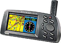
After hearing about Garmin's support for WAAS on their GPS 295
I spent some time reading up on it and trying to understand what WAAS is, what
LAAS is and what GPS IIf is? Below you will find a very short description
on the different technologies that promise to enhance our existing GPS
systems. This article pulls together information spread out all over
the Internet and is aimed at Pilots.
NOTE: I am still trying to refine my own understanding
of this stuff so don't hold my feet to the fire here. Expect updates as I
learn more. There What is DGPS It will help if I start with DGPS first
to explain WAAS and LAAS.
Remember DGPS which was "Differential GPS"? DGPS was a system
where an airfield, like LAX, would put in a special transmitter on the ground
that sends a special signal to a "Differential Receiver" that you
would have to buy. The DGPS receiver plugs into your GPS. This
signal removes all of the error that the military was introducing and it would
further improve the accuracy by removing the error caused by slight errors in
satellite orbit and errors introduced by the atmosphere and the miniscule errors
on the GPS atomic clocks. The objective was to improve the accuracy of
your GPS receiver so you could shoot an ILS approach with it, possibly down to
CAT III.
|
After hearing about Garmin's support for WAAS on their GPS 295 I spent some time reading up on it and trying to understand what WAAS is, what LAAS is and what GPS IIf is? Below you will find a very short description on the different technologies that promise to enhance our existing GPS systems. This article pulls together information spread out all over the Internet and is aimed at Pilots.
NOTE: I am still trying to refine my own understanding
of this stuff so don't hold my feet to the fire here. Expect updates as I
learn more. There
It will help if I start with DGPS first
to explain WAAS and LAAS.
Remember DGPS which was "Differential GPS"? DGPS was a system
where an airfield, like LAX, would put in a special transmitter on the ground
that sends a special signal to a "Differential Receiver" that you
would have to buy. The DGPS receiver plugs into your GPS. This
signal removes all of the error that the military was introducing and it would
further improve the accuracy by removing the error caused by slight errors in
satellite orbit and errors introduced by the atmosphere and the miniscule errors
on the GPS atomic clocks. The objective was to improve the accuracy of
your GPS receiver so you could shoot an ILS approach with it, possibly down to
CAT III.
As you know, the military removed the error that they were
introducing. I think the FAA saw the potential that almost any airport
could get a CAT III approach if they could afford enough equipment... I
have a feeling that this idea died because of cost and maintenance of all those
DGPS equipment installations that would have to be made at each airport that
wanted to use GPS for precision approach.
WAAS... This stands for "Wide Area
Augmentation System". WAAS is really the same thing as DGPS (see
above) except it uses
new version of satellites instead of a ground station. The FAA is launching satellites into space that
transmit the correction information to your GPS using the SAME radio band as the
current GPS system. This is cool because it doesn't require you to buy
anything, you just upgrade your GPS (if the manufacture built in this
capability). An example is the Garmin 295. Instructions to upgrade
it are mentioned below.
The way it works is the WAAS satellite listens to ground stations that spends their life figuring out what the error is for each satellite orbit, the error is that is induced by the atmosphere, and any errors in the satellite's clock. It tells the WAAS satellite system this information and it in turn tells your GPS receiver. Bingo---> your accuracy goes down to + - 2 meters vertically and 3 meters horizontally. The WAAS satellites are geo-stationary and the plan is to only position them over the US. Therefore, if you fly to another country, this improved capability will not be available, even if you can still receive the WAAS signal. This is because there are no plans to have WAAS ground stations in that country. One counter indicator of this is an announcement by the FAA that they successfully completed the first test flight in Chile to demonstrate world-wide use of WAAS (ref. http://www.faa.gov/apa/pr/pr.cfm?id=605). Several countries are planning their own signal correction systems including Japan, and Europe. Some countries desire to work with the US to deploy WAAS systems of their own, others are using something else.
In addition to accuracy improvements WAAS
also provides information on the status of the GPS system. Should there be any
problem, it will send a signal to your receiver that the GPS system
should not be trusted (this is aimed mainly at IFR approach
approved receivers). When this happens I think your IFR GPS will notify
you..
According to original FAA statements, WAAS will improve GPS accuracy to approximately 7
meters vertically and horizontally. According to a statement made by the
FAA on 8/21/00, the accuracy is at one to two meters horizontally and two to
three meters vertically throughout the US. (ref. http://www.faa.gov/apa/pr/pr.cfm?id=1135).
WAAS satellites also act as standard
GPS satellites so your GPS uses them if they are available. The FAA will
be able to quickly certify airports to CAT 1 for WAAS enabled IFR GPS systems
for many airports. According to one independent web site, accuracy has
improved to under 3 meters. But what about CAT III approaches will be
available using LAAS (see below)
(See http://www.gpsinformation.net/exe/waas-comp.html )
As of 5/2001 there are only two WAAS satellites up in the sky and are they are basically running in "test mode". From the technical info I have seen these satellites send all kinds of different information to your GPS in order to set time, communicate status and other data.
LAAS stands for "Local Area Augmentation System". LAAS is basically the same as DGPS. It uses a ground station like DGPS and improves the accuracy even more than WAAS for a small area. It will be so good that they will be able to offer CAT II/III approved approaches (with auto land) if you have the right equipment. It will require additional hardware to receive the special signal. The reason that LAAS is on the drawing board is because WAAS will only be accurate enough for CAT 1. LAAS will also be used where WAAS doesn't reach. An example might be where there are mountains blocking WAAS signals.
GPS IIf is just the next version of the GPS satellites. I understand that the current version is GPS IIe... I am not sure what the features are for the next generation GPS satellites. One thing that I read is that it will have better clocks. They are currently "analog" atomic clocks. From what I can gather, they will be making them "digital" and possibly self correcting. Although atomic clocks are super super accurate, a change of only a few 1000s of a second can affect GPS accuracy because of the distances involved. Currently ground stations upload corrections to the satellites. These are just some of the enhancements that will improve GPS system accuracy.
To setup WAAS support for your Garmin 295, download and install version 2.20 or later software (found here). You can get it from the Garmin site. After the software upgrade, You still need to enable WAAS support. Go to the main setup menu and you will see a new option at the bottom called "WAAS". Initially it will be disabled. Put the cursor on the "WAAS" field and press "Enter" and choose "Enabled".
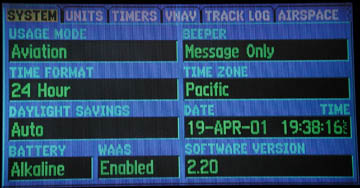
Notice the "WAAS" field at the bottom of the
setup is set to "Enabled".
I am not sure exactly what the implications are for doing this since I haven't been able to do a lot of testing yet. The main difference that Pilots will notice is the improvement of altitude. Currently my GPS 295 can be off by more than 1000 feet. There is practically nothing on the Garmin WEB site that talks about the implications (or even how to enable once the software is installed at this writing). What you will notice is that there are two new satellites that will always occupy the last two positions on the satellite status map, satellites 33 and above. This may impact your GPS because it can now only track 10 normal GPS satellites since the last two positions are taken by the WAAS GPS units. These WAAS GPS satelites act like normal GPS satelites but are difficult to see on the ground because they sit a little lower on the horizon. I don't think this will be an issue though if you use it for navigation in an airplane since you are normally high enough to see both the east and west satellites and normally 10 others.
When the GPS picks up the WAAS satellites it slowly, put a "D" in each bar for the satellites that it was tracking to indicate that it was receiving correction information (WAAS satellites received a D first). Eventually all of them had it and the GPS stated that it was in "Differential 3D Navigation" mode. The error went from 17 feet to 13 feet and the DOP rating fluctuated between 1.1 and 0.8 with the built-in antenna in a parking lot. I am expecting better performance with the external antenna and being in an environment where the multi-pathing will be less of an issue (signal bouncing off other cars).
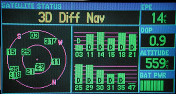
Notice the "D" on each of the signal strength
indicators indicating that the GPS has received the correction information for
each one. The correction information is being provided by satellite #35,
Atlantic Region West satellite. Also notice the caption at the top,
"3D Diff Nav" showing that the unit is in differential mode.
While the unit was capturing the correction information, some of the signal
strength indicators did not have a "D". Lastly, notice that the
Pacific Region satellite, 47, was being blocked so it never came up. Oh
and other other thing. If your GPS is setup correctly, the last two place
holders will be for WAAS enabled satelites, even if you can't receive them (due
to line of site problems).
In order to receive the differential signal information for correction, your GPS must be able to see a WAAS satellite, #33 or higher.
The web page at http://www.gpsinformation.net/exe/waas.html shows a description of each of the planned or existing WAAS enabled satellites and the associated Garmin satellite ID.
There is data on the web at http://www.gpsinformation.net/exe/waas-comp.html that shows results from independent testing (these guys are really into it.). Look at the figure at the bottom of this page where they just sat the GPS on top of a car. Because the signal bounces around off the car it can increase the error.
Picking up the satellites may be difficult because they are low on the horizon in geo-synchronous orbit.
WAAS satellites can be taken off line during this phase of deployment. Status information can be found at http://wwws.raytheontands.com/waas/.
I will add more for the article on the web. I am still doing some research.
I've had difficulty getting reception of the WAAS satellites while on the ground because they sit a little low on the horizon but without a whole lot of work, my GPS can receive both the east and west satellites.
I have see accuracy for altitude while flying be + or - 30 feet or less. I think there are several factors for this. Pressure settings are either set at your departure airport or set for a given area from ATC. These areas can be quite large. Combine this with accuracy of the old aircraft altimeters and I'm willing to guess that the scientists are probably correct about the accruacy. As for horizontal position accuracy, I will have to just bolieve the other experts out there. Unless you know your exact latitude and logitude how can you really know. If you see an error on the map display, is it the map database or is it the GPS (I'll bet the map is off). For non IFR, plus or minus 20 feet horizontal accuracy while traveling at over 120 mph (which is 88 feet per second) is close enough for me!!!
I have two annoyances with my Garmin GPS 295.
Expect an update to this section as we gain more experience with
the unit and if you find anything, let me know via e-mail by using the link
below.
Joe Mehaffe and Jack Yeazel's GPS Information Website.
FAA Completes Successful WAAS Flight Trials in the Republic of Chile
FAA WAAS availability announcement dated 8/24/2000
IEEE Proceedings, January, 1999, Vol 87, #1